
Harvard Graduate School of Design
Landscape Architecture and Planning
University College London
Centre for Advanced Spatial Analysis
Abstract
The Cambridge-Milton Keynes-Oxford (CAMKOX) Corridor is the fastest growing region in the United Kingdom. The UK National Infrastructure Commission proposes to add 780,000 housing units and 1,450,000 people to the existing CAMKOX population of around 3,300,000. However, it is highly likely that the conditions under which this objective would be met by 2050 will be substantially different from those of today. The direct and indirect impacts of projected climate change, demographic growth and technical innovation must be considered in relationship to current conditions. In this context, a two-day workshop was organized among interested stakeholders by the Centre for Advanced Spatial Analysis of University College London, with the participation of 20 professional planners and academics with CAMKOX experience. Geodesign modifies geography by design at intentional change. It tightly couples the creation of proposals for change with impact simulations informed by geographic contexts and systems thinking. Coming to a politically acceptable planning strategy inevitably implies negotiation among local people, aided by geographic scientists and design professionals, supported by information technologists. The digital tools to enable a collaboratively negotiated consensus are based on diagrams of policies and projects to produce an outcome only indicating that “It can be…or might be… something like this”. Participant teams each applied one of three scenarios of early, late, or non-adoption of systems policy and project innovations, reporting the designs and their impacts at three time-steps, 2020 (existing), 2035, and 2050. These were compared and negotiated to one final design.
Keywords
Climate change, Demographic growth, Land use change, Stakeholder collaboration, Geodesign, Negotiation
Recibido
April 30, 2021
Aceptado
December 20, 2021
On planning for significant change
For real and serious societal and environmental issues, intentional planning for change —planning by design— is inevitably a collaborative endeavor, with participants from various design professions and geographic sciences, linked by technology for rapid communication and feedback, and reliant on transparent communication with the people of the place who are also direct participants. The people of the place are not just the clients; they are the designers as well. Quoting Herbert Simon in his 1978 Nobel Prize lecture, “Everyone designs who devises courses of action aimed at changing existing situations into preferred ones” (Simon, 1996). However, it is highly likely that the conditions under which this objective would be met by 2050 will be substantially different from those of today. The direct and indirect impacts of projected climate change, demographic change and technical innovation must be considered in relationship to current conditions. Coming to a politically acceptable planning strategy, inevitably implies a negotiation among local inhabitants, aided by design professionals and geographic scientists, supported by information technologists Geodesign changes geography by design, by tightly coupling the creation of proposals for change with impact simulations informed by geographic contexts and by systems thinking (Batty, 2013). Geodesign must developed in a framework with an organized process, in (Rowe, 2017; 1987). It must be collaborative, and it cannot be effective if conducted in separate bureaucratic compartments (Pettit et al, 2019). It is most useful at the early stages, by considering strategic change, when there is simultaneous need to consider all aspects of change: the “WHY?” questions, the “HOW?” questions and the “WHAT, WHERE and WHEN? questions (Hollstein, 2019). It is best accomplished in a face-to-face workshop setting, albeit possibly in these times among remote participants who are linked by technology. It can be supported with efficient digital tools (Ballal, s.f.; 2015) which enable a collaboratively negotiated consensus based on diagrams of policies and projects and, if successful, produce an outcome which indicates that “It can be…or might be… something like this”.
On geodesign
Geodesign is a method which tightly couples the creation and synthesis of diagrammatic policy and project proposals for change with impact simulations informed by geographic contexts and by systems thinking (rather than shape thinking). It is normally supported by digital technology, and it is organized by a systems-oriented framework for geodesign which asks and answers six relevant questions that apply to any geodesign circumstance (Figure 1):

Six questions must be asked and answered for any geodesign circumstance.
Source: Steinitz (1990; 2012).
> How should the context be described?
> How does the context operate?
> Is the current context working well?
> How might the context be altered?
> What differences might the changes cause? and
> How should the context be changed?
Geodesign is a design process that is normally organized for collaborative, negotiated decision making. It is especially applicable to large, complex and contentious circumstances related to planning for the future. Thomas R. Fisher (2016) describes geodesign as “a geo-spatial approach to grand challenges … allowing communities of people with common interests to find each other as well as to generate alternate ways of addressing a challenge”. It enables different stakeholders to work together, and with scientists, design professionals and information technologists in a digitally supported process where the impacts of proposed designs are shown in real time. What makes geodesign interesting and innovative is that the process is geared towards negotiation among different stakeholders seeking to strike a compromise (Figure 2). It attempts to shift the paradigm from a zero-sum game to a win-win situation.
A geodesign workflow puts systems thinking into practice. Geodesign is normally a collaborative enterprise, so a geodesign study must be undertaken in a way that is understandable by all participants, especially by the people of the place. The basis for shared understanding includes the ability to conceive individual policies and projects and combine them into comprehensive designs. The process of combination is challenging. A design is a synthesis of decisions in space and time that brings about system-based change. Any individual change, no matter how seemingly localized, affects the system as a whole and can influence what is subsequently feasible and preferable.
For example, the decision to align a road in one place or another (or yet another still) will affect the possible later location of housing or commercial developments. Because of and despite the complexity, rapid design iterations are critical in geodesign, so there must be the ability to rapidly assess potential impacts and costs of design proposals. Here, there are more challenges.
Feedback relationships among individual design propositions require that representation, process, and evaluation models be updated to consider additional design changes. Given the amount of data and need for data updates, digital platforms for collaboration and communication usually form the basis of the geodesign workflow. Geodesign has been developed in many ways and by many contributors (Fisher, Orland & Steinitz, 2020; Goodchild, 2010), It has most frequently been applied to the initial planning stages of problems which are politically contentious, and these inevitably require negotiation to achieve consensus. The two most common circumstances are when the people of the place disagree among themselves with what the problem is and what should happen, and when those who are responsible for providing guidance in the form of a designed proposal work in separate “silos” rather than in direct collaboration and disagree about what should be proposed (Figure 2).
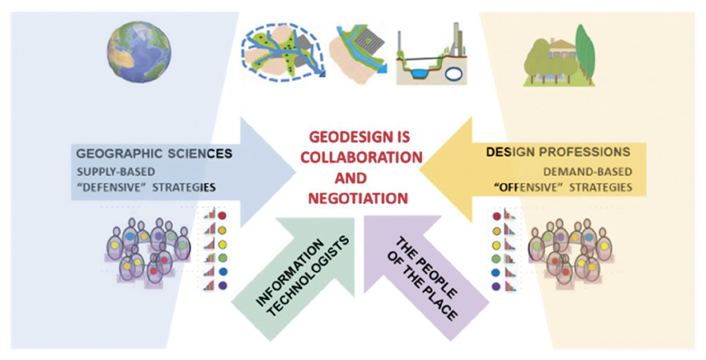
Geodesign is collaboration and negotiation.
Source: elaborated by the author.
On negotiation as a geodesign method
Negotiation is the most important method for arriving at political consensus regarding future change. It is applicable across size and scale. When seen across a range of problem sizes and scales, collaborative negotiation in geodesign is especially applicable in this middle range (Figure 3). At the global scale, the geographic sciences provide excellent guidance, and at the small project scale the design professions provide excellent service. The mandate for collaboration especially occurs in the middle range, where supply based “defensive” strategies need to be balanced with demand based “offensive” strategies, and where the people of the place, who are assumed not to agree with each other, have the major political role. Coming to a politically acceptable planning strategy inevitably is a collaboration among the people of the place, aided by geographic scientists and design professionals, and supported by information technologists. These people must have a basis for understanding, communication, collaboration, and negotiation. This is not easy to achieve.
Frequently, but not necessarily, geodesign is delivered through a workshop setting. The geodesign process will make use of diagrams of proposed policies and projects to develop stakeholders proposed future plans.
This technique of using diagrams and their assessments in standardized colors serves as a shared visual language that enables understanding and communication among workshop participants. It enables participants to select from the range of diagrams, and to edit or add new diagrams to create a final negotiated proposal for the study area. The result is not as data rich as normally recognized in a GIS, nor as detailed as required by BIM. It is nonetheless extremely useful when confronting a large, complex, and contentious problem.
The CAMKOX corridor workshop: re-thinking growth in the London Region
The Cambridge-Milton Keynes-Oxford Corridor, hereafter the CAMKOX Corridor, spans 30 local councils comprising the growth corridor from Oxford through Milton Keynes and Northampton to Cambridge. It is the fastest growing region in the UK.
It forms the northern fringe of the Greater London City region to which it is profitably tied, just north of the Green Belt. History, knowledge, technology, agriculture and nature combine in a rich tapestry that has long contributed to the commonwealth of the United Kingdom. In a globalizing world where distances of all kinds are slashed, the CAMKOX Corridor (Figure 3, the blue-outlined area). is more than a key part of the greater London region. It is a gateway north to the Midlands and the “Northern Powerhouse” The United Kingdom’s National Infrastructure Commission proposes to add 780,000 housing units in the CAMKOX Corridor and 1,450,000 people to the existing population of around 3,300,000.

The CAMKOX study area, Cambridge, Milton Keynes and Oxford.
Source: elaborated by the author.
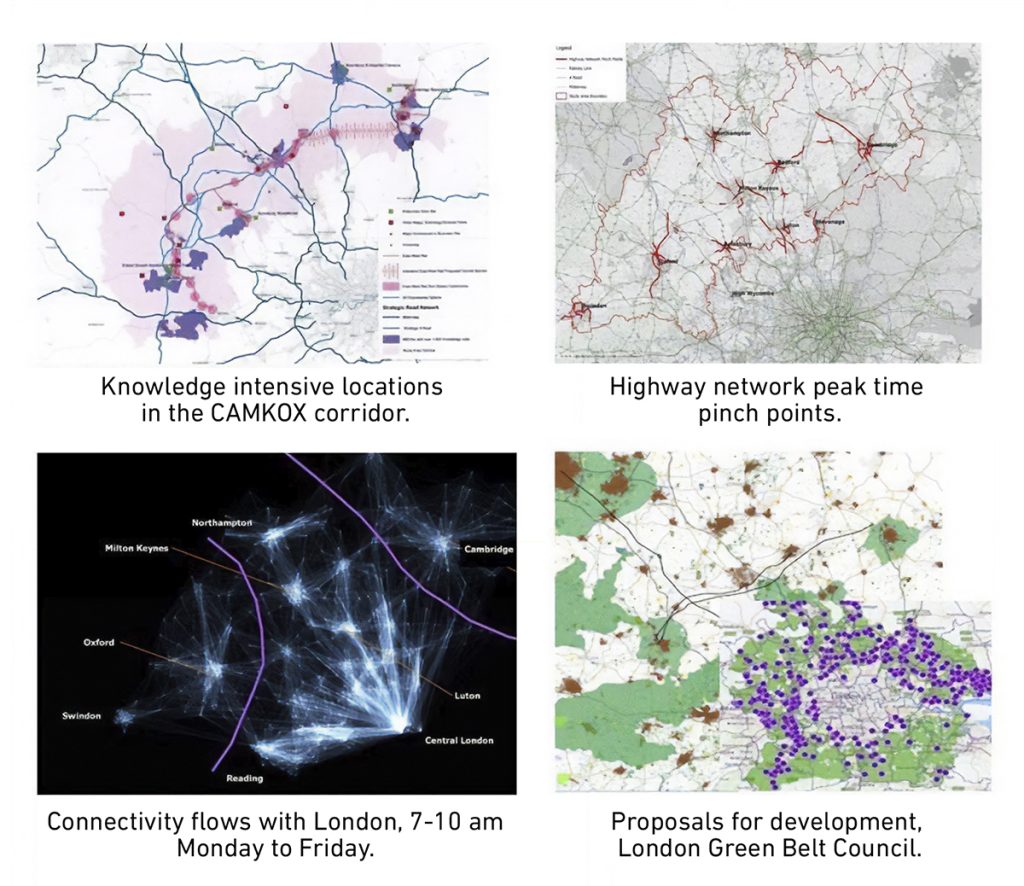
Traversing the corridor from south to north is the proposed high-speed rail line HS2, as well as the planned east-west and east-west rail line linking Oxford to Cambridge through Milton Keynes. These transport links, taken together, are intended to enhance connectivity, mobility and productivity across the region. Other impacts of growth also need to be addressed, such as last mile connectivity and multi-modal transport, social inequities, land consumption of agriculture and forests, greater flood risk, pollution, and loss of ecological function and integrity of this historical region including its villages and towns (Figure 4). These impacts need to be addressed by an assessment of growth scenarios and their impacts, in advance of major infrastructure projects.
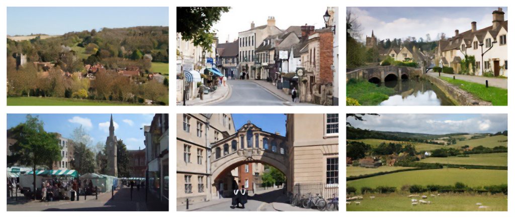
CAMKOX corridor scenes.
Source: elaborated by the author.
CAMKOX Issues.
Source: elaborated by the author based on images of the CAMKOX Workshop.
There are important complications, Figure 5 shows some of these issues:
> The new high-speed train, HS2, does not connect with the CAMKOX Corridor’s train, and it is not planned and therefore will not be built to do this in the near future.
> The right-of-way of the former train linking Cambridge with Bedford (and on to Oxford) was sold and substantially developed when the train closed in the 1980s.
> There is considerably more travel demand from CAM, MK and OX to London, and into CAM, MK and OX from their immediate sub-region, than from OX to MK to CAM.
> The London policy to maintain its greenbelt is under pressure from many proposed developments, and the availability and price of London housing is a major political issue.
> There is organized opposition to the proposed development of the region.
The CAMKOX Workshop was organized by The Centre for Advanced Spatial Analysis of the Bartlett School, University College London in a two day in November 2018 using geodesignhub technology. The participants were 20 professional planners and academics with knowledge of and experience in the issues embedded in the workshop.
The workshop was structured by the conventions of the International Geodesign Collaboration (Figure 6) (IGC, 2018). It adopted the IGC systems as the basis for design, e.g., green infrastructure, transportation, energy infrastructure etc., it applied the three scenarios of early-, late-, and non-adopters of systems policy and project innovations, it reported the impacts at three time-steps, 2020 (existing), 2035, and 2050, and it comparatively assessed the three final 2050 designs according to the United Nations Sustainability Development Goals, SDGs.
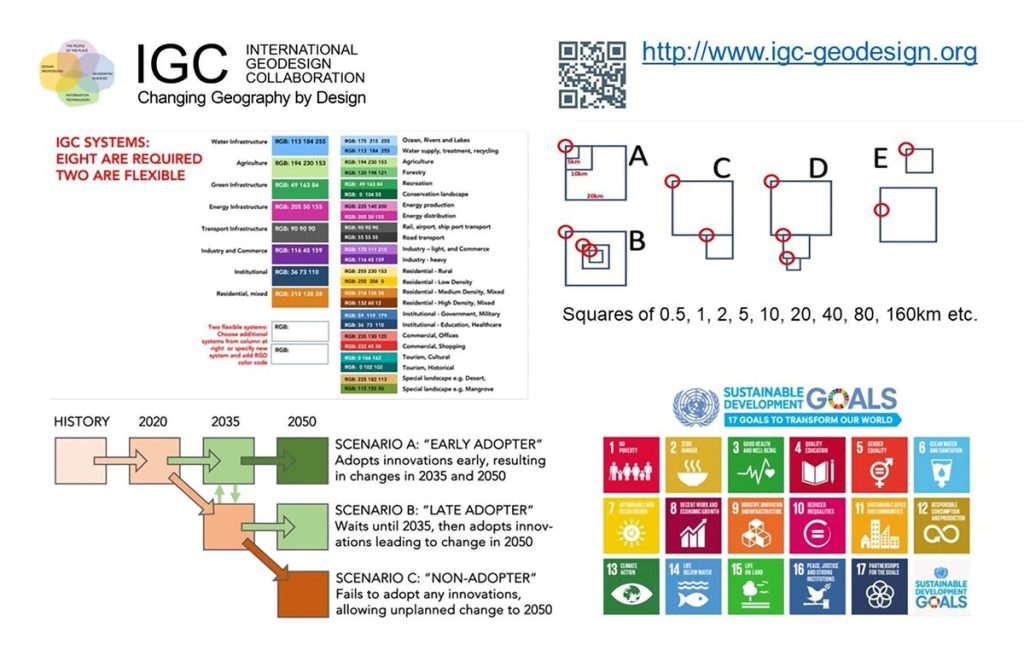
IGC 10 systems, square study areas, 3 scenarios & UN Sustainable Development Goals.
Source: elaborated by the author.
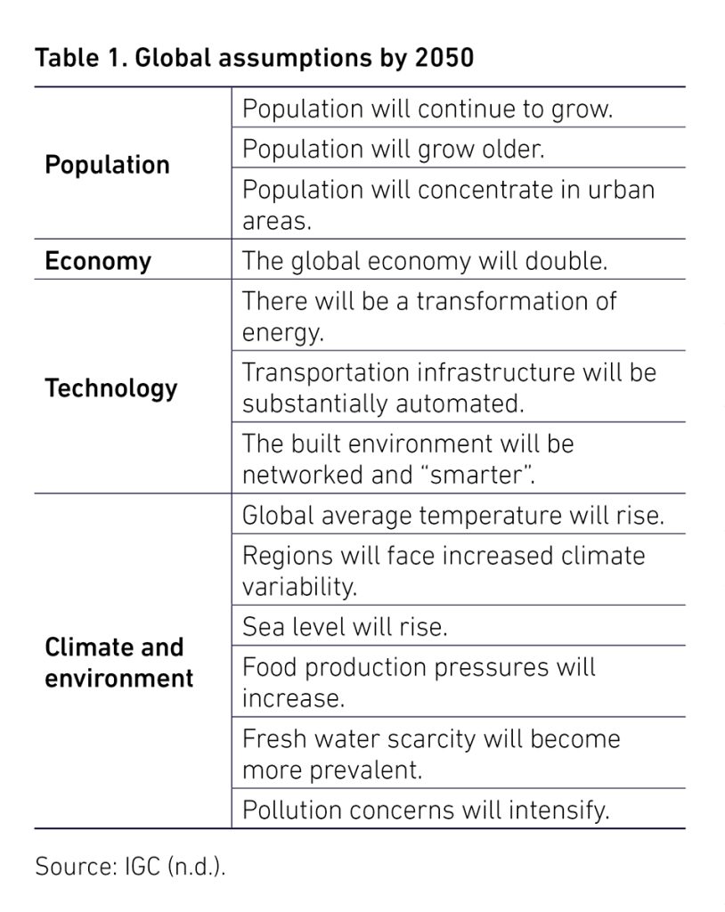
The International Geodesign Collaboration (IGC, n.d.) had identified 12 global assumptions which should guide longer-term planning (Table 1).
The locally adopted geodesign innovations which guide the scenarios are selected from more than 150 prospective global innovations which were identified through the research of the International Geodesign Collaboration (IGC, n.d.). Some of these are based on expectations derived from forecasts related to climate change such as environment-controlled agriculture, water retention, carbon mitigation and increased electric-based transport, while some derive from social and demographic changes which require additional land-use devoted to urban development, and some derive from expected technical innovations related to utility and transportation systems.
Geodesignhub is a cloud-based, free and open access, open platform software built by Hrishikesh Ballal (Figure 7). It is designed to link with other tools and models via an application programming interface (API), rather than to contain its own complex data, models and visualization tools. It is used to manage geodesign for large, complex, politically contentious projects and studies in their early conceptual and strategic phases when the process is at its most dynamic. It is designed to support collaboration and negotiation.
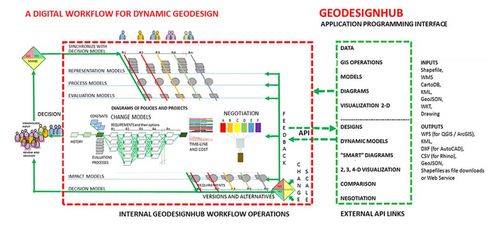
Geodesignhub – a digital workflow for geodesign.
Source: Geodesign Hub.
Geodesignhub aims to be as simple as possible: easy to learn, set up, use and (most importantly) easy to understand. The tool allows participants to easily change their proposed plans as they work through several reiterations of their designs in response to evaluations related to the characteristics of the study area.
Further changes resulting from collaboration and negotiation with other participants can be made quickly and evaluated on the spot. It includes tools to support comparison among designs and negotiation towards agreement. These aspects of Geodesignhub were the focus of the CAMKOX case study.
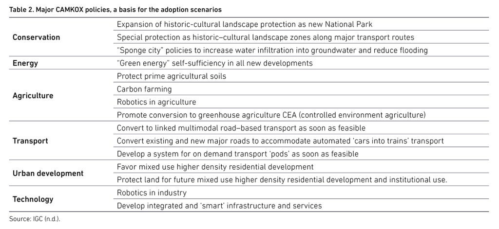
The pre-workshop organization had four main tasks. Designing the workshop’s content, workflow and timing was accomplished in two meetings among key CASA participants. IGC research teams had identified more than 150 innovations which might be expected by 2035 and 2050 (IGC, n.d.). These were assessed and the following were those selected for the set of CAMKOX workshop assumptions (Table 2).
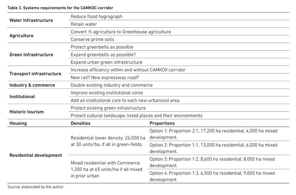
The ten IGC systems and the growth assumptions of the National Infrastructure Commission to add 780,000 housing units and 1,450,000 people to the existing population of around 3,300,000 in the CAMKOX Corridor were accepted as the basis of the workshop requirements (Table 3).
Initial diagrams of policies and projects for each of the ten systems were drawn from finalist presentations in the CAMKOX Corridor ideas competition managed for the UK Infrastructure Commission (Figure 8).
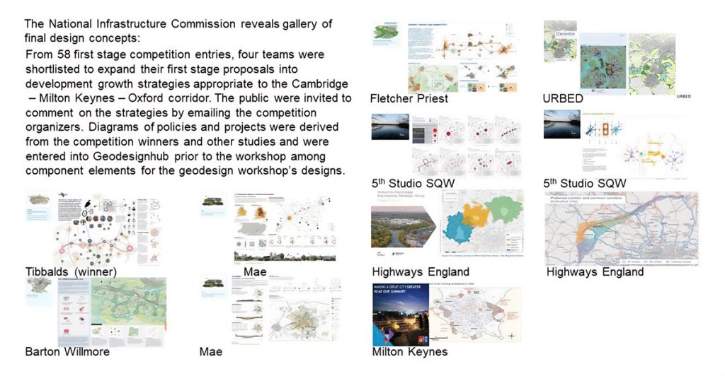
Final Design Concepts, National Infrastructure Commission.
Source: elaborated by the author based on the shortlist announced for The Cambridge to Oxford Connection: Ideas Competition.
These were expanded and edited during the workshop (Figure 9). Most of the additions and edits were related to the expected innovations.
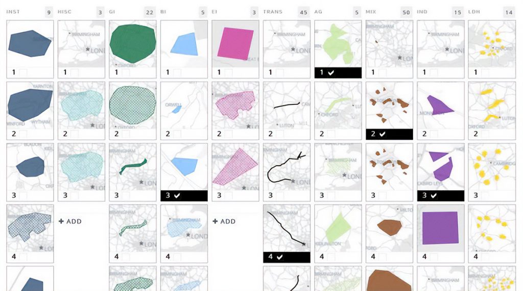
Initial diagrams from The National Infrastructure Commission competition.
Source: elaborated by the author based on Malcolm Reading Co. (s.f.).
In the first day of the workshop, and after an introduction and learning the basic operations of Geodesignhub, the participants in the workshop were organized into six teams based upon the IGC scenarios of early, late and non-adoption of innovations.
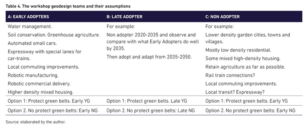
Two teams represented each scenario, with one to protect and one to choose to protect or alter the current greenbelts of London, Cambridge and Oxford (Table 4). Each pair would then negotiate a single scenario design (Figure 10).
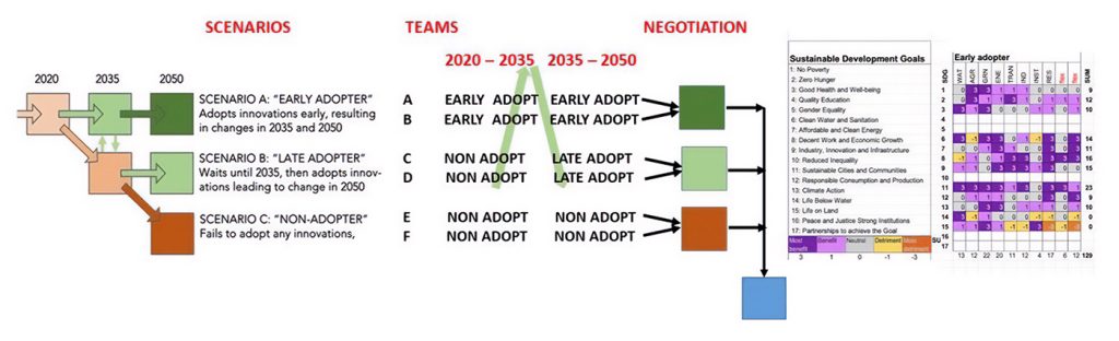
Scenarios, teams and negotiation sequence.
Source: elaborated by the author.
Scenario A, the Early Adopter assumes that the team is looking forward to the year 2050 and is planning now for innovations that are forecast to be available by that time. Nonetheless, it must present a plan that begins in 2020 and carries forward to the agreed stage one planning date of 2035. This leaves the Scenario A team with an important choice (for this workshop): do we first make a design for 2050 and work backwards to a first-stage design for 2035, thus leaving maximum flexibility to a future at some cost for the first 15 years, or do we directly make best a plan for the first stage and its innovations and then add a plan for the second stage and its innovations to the year 2050?
Scenario B, the Late Adopter assumes that for any of a set of reasons such as financial ability, social competition, political conservatism etc., the likelihood of adopting innovations is unlikely or infeasible in the period 2020–2035. Therefore, its design will carry forward current policies and societal practices (as the team judges to be appropriate). It further assumes that conditions will have changed in 2035 and especially because of the ability to observe other places which have made innovative changes during this first stage. It therefore assumes a change in attitude and that things which have been successful in 2020–2035 (as represented in this workshop by the scenario A “Early Adopter” teams) can be adapted for a second 2050 stage of its own first stage design. For this workshop, the team therefore needs to select one of the Scenario A 2035 designs and adapt its policies and projects into its own design for 2050.
Scenario C, the Non-Adopter also assumes that for any set of reasons such as financial ability, social competition, political conservatism etc., the likelihood of adopting longer term innovations is unlikely or infeasible in the period 2020–2035. Therefore, its design will carry forward current policies and practices (as the team judges to be appropriate). It further assumes that conditions will not have changed by 2035, and it therefore needs to continue these policies and projects in its second stage design to 2050.
Each team selected, added or edited policy and project diagrams to generate its Version 1 proposals for 2030 and 2050. These were assessed for their impacts and costs and revised at least once, for Version 2 and again assessed (Figures 10 and 11).

The Version 2 designs at the end of the first day.
Source: elaborated by the author.
On the second day, the teams began informal negotiation as they all knew that one objective of the workshop was to generate a negotiated solution for the region. This initial negotiated set of alternatives was Version 3, and it was again assessed.
The workshop then used a sociogram to determine the mutual proclivities for formal negotiation. These were based either on the similarity of designs or their potential symbioses. Two rounds of negotiation were conducted using Geodesignhub tools and this produced the final negotiation designs for 2035 and 2050 (Figures 12 and 13).
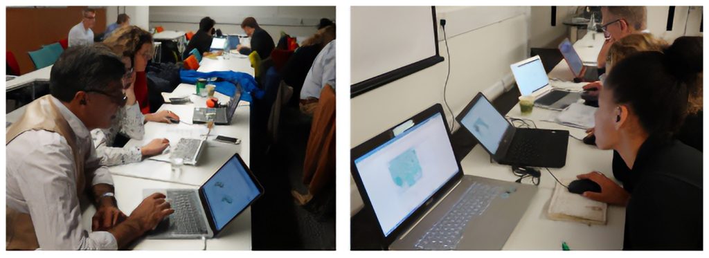
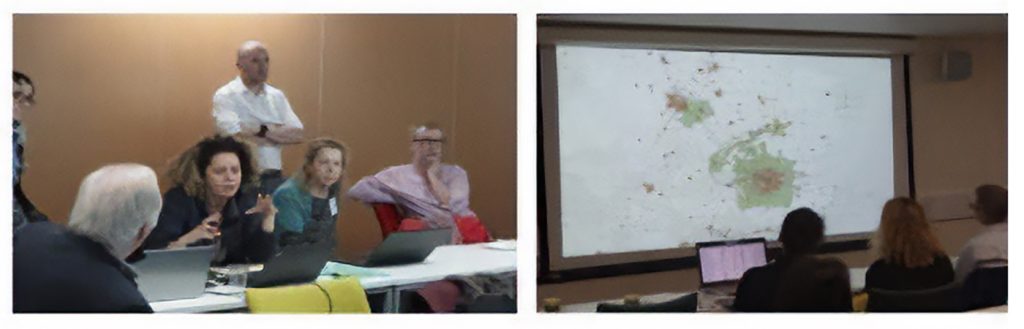
Left: Making the design.
Right: Negotiation.
Source: elaborated by the author based on images of the CAMKOX Workshop.
The Early Adopter teams (Figures 14 and 15) first protected the region’s major assets and developed urban patterns that were denser than the past development of the area. They introduced conservation policies for prime soils, water, agriculture, and the historic-cultural landscape. They retained the London greenbelt but not all of those of Cambridge and Oxford, while also promoting a new national park and large regional expansion of linked conserved landscapes.
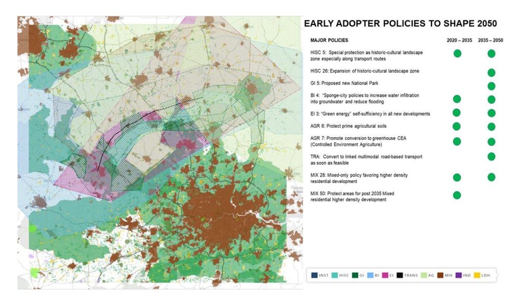
Early-Adopter policies
Source: elaborated by the author based on images of the CAMKOX Workshop.
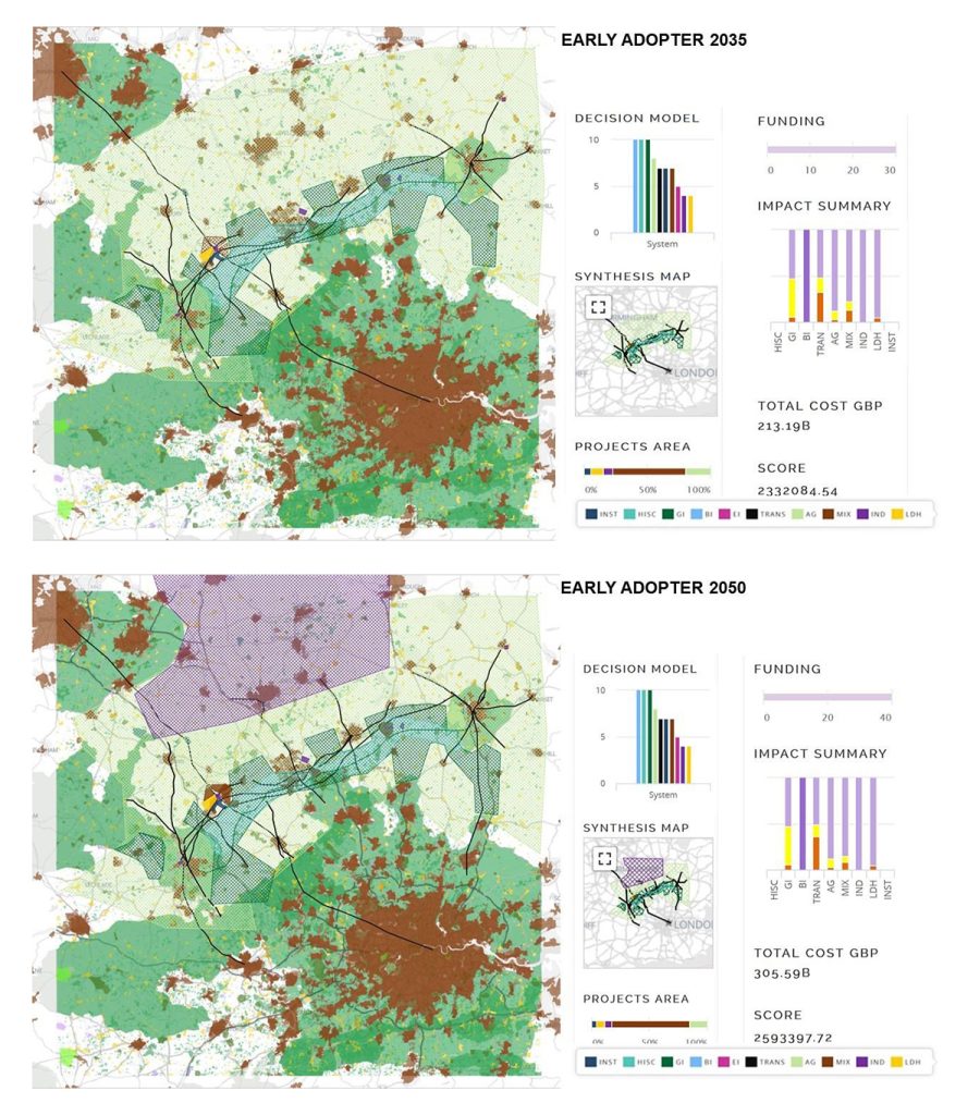
Early-Adopter 2035 and 2050.
Source: elaborated by the author based on images of the CAMKOX Workshop.
An important decision was to designate large areas of non-prime soils for conversion to industrial scale, controlled-environment agriculture, based on climate change and the need for multiple and more diverse food crops.
Urban development was focused on mixed higher density residential and services and concentrated along the CAMKOC corridor. This also retained the highly dispersed pattern of villages and towns. One urban development area which is preplanned by 2035 is at the intersection with HS2 and is based on a proposed multimodal transfer point at this location.
The most controversial aspect of their decision making was to not rebuild the train link between Cambridge and Bedford, and to rely on the future development of multimodal transport on roads designed and redesigned for electric, self-driving and probably use-rented car-based trains. This was in large part a reflection of the existing highly distributed network of smaller communities and lower overall regional densities. Train links would continue to be improved between the major towns and London and northern cities.
While recognizing growth pressures, the Late Adopter teams (Figure 16) reflected the conservative planning attitudes that characterize the region. The Non-Adopter teams (Figure 17) accepted the proposed expressway and train plans of the National Infrastructure Commission, relocating and remaking the Cambridge to Bedford train link by 2035. They continued the preferred lower density development patterns, and distributed growth among many of the smaller towns in the region. This reflected the NIC’s preferred competition winners’ proposals. The exception is in Milton Keynes’ plan for higher density mixed development by 2026. Their conservation was focused on retaining agriculture and its associated landscapes and villages. These overarching policies and projects were continued to 2050, enlarging the distributed, town-based lower density development pattern throughout the CAMKOX Corridor.
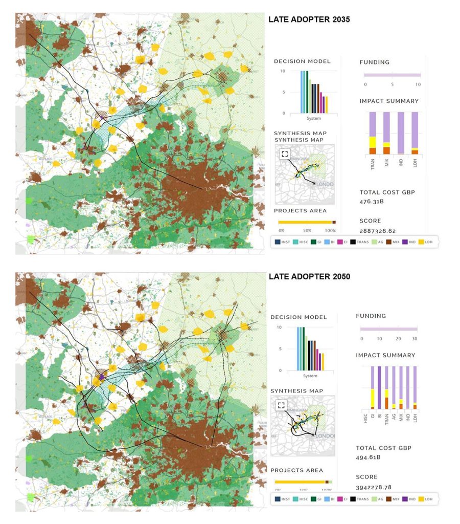
Late-Adopter 2035 and 2050.
Source: elaborated by the author based on images of the CAMKOX Workshop.
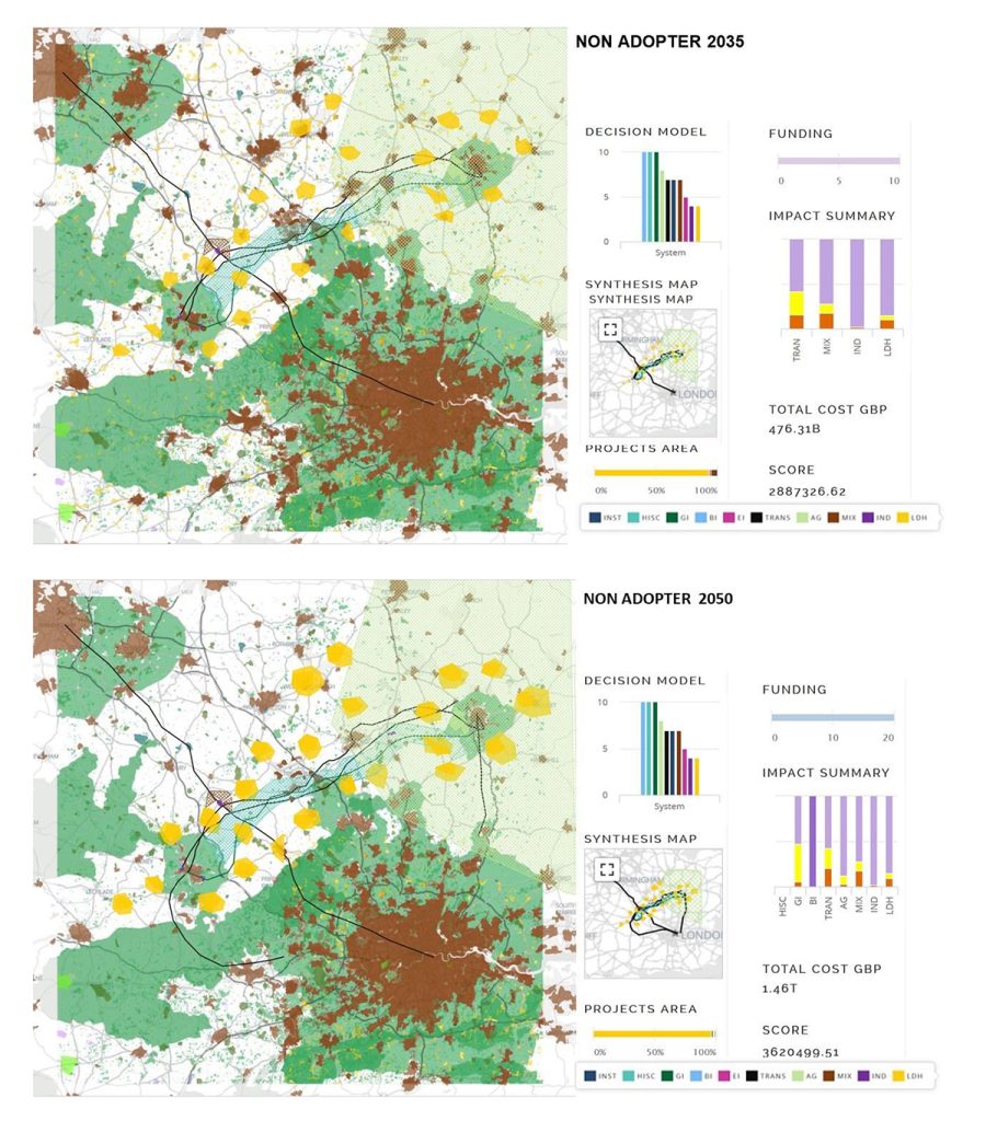
Non-Adopter 2050.
Source: elaborated by the author based on images of the CAMKOX Workshop.
In the final negotiation process of the workshop, it became clear that the negotiating participants favored the innovative policies and projects preferred by the Early Adopter teams. Despite the market favouring lower densities (Figure 18), these were principally related to favouring (encouraging) the innovative higher rather than lower densities for the CAMKOX corridor, but not to the total exclusion of some concentrated areas of lower density.
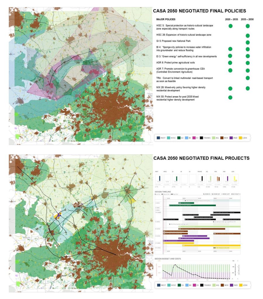
The final negotiated design 2050.
Source: elaborated by the author based on images of the CAMKOX Workshop.
After 2035, the central policies of the Late Adopter team changed in favour of the innovative policies and projects developed between 2020 and 2035 by the Early Adopter teams. They adopted innovative policies and projects and promoted mixed higher density development, in part to support the prior infrastructure investments. This also involved proposing a link between the reestablished train infrastructure and HS2. Conservation was focused on special protection for the most travelled tourism zone.
After considerable discussion, the negotiating participants placed great emphasis on growing the existing settlements along the major transport corridor spine. They did this with an emphasis on automated private vehicles in a new highway designed for efficient linking into “trains”, rather than an emphasis on rebuilding the train network that formerly existed. The major reason for this was the existing and highly distributed location of industries and institutions throughout the region and the need for the existing transport system to have additional links to these many locations.
The equivalent of a new small city similar to that proposed by the Early Adopter teams would be developed around the intersection of the new high-speed London to the north train and both the existing Oxford to Cambridge line and the new road developed for car-trains. This would be a major hub for industry, health and university services, and mixed high-density living.
Priority was also given to protection of the existing high-quality landscape and the historical assets of the corridor. This was accomplished through the design of policies to protect the equivalent of a new National Park which provided both landscape protection and green infrastructure connections throughout the greater region.
Current agriculture and urban uses would be maintained; a change would be carefully managed. It was noted that the configuration of the protection zone enabled each of the major urban areas an unprotected direction for substantial later urban expansion. The agricultural policies were also controversial.
Whereas the Early Adopter teams proposed a major zone of controlled environment agriculture to the north and outside the CAMKOX corridor on second priority soils, the negotiators decided that except for the zone of priority landscape protection, a more individualized and decentralized agricultural conversion policy should be adopted.
Figure 19 shows that the Early Adopter strategy was superior to the Late Adopter which was in turn superior to the non-adopter strategy of innovation adoption. It is the scenario which can best adapt to climate and demographic expectations.
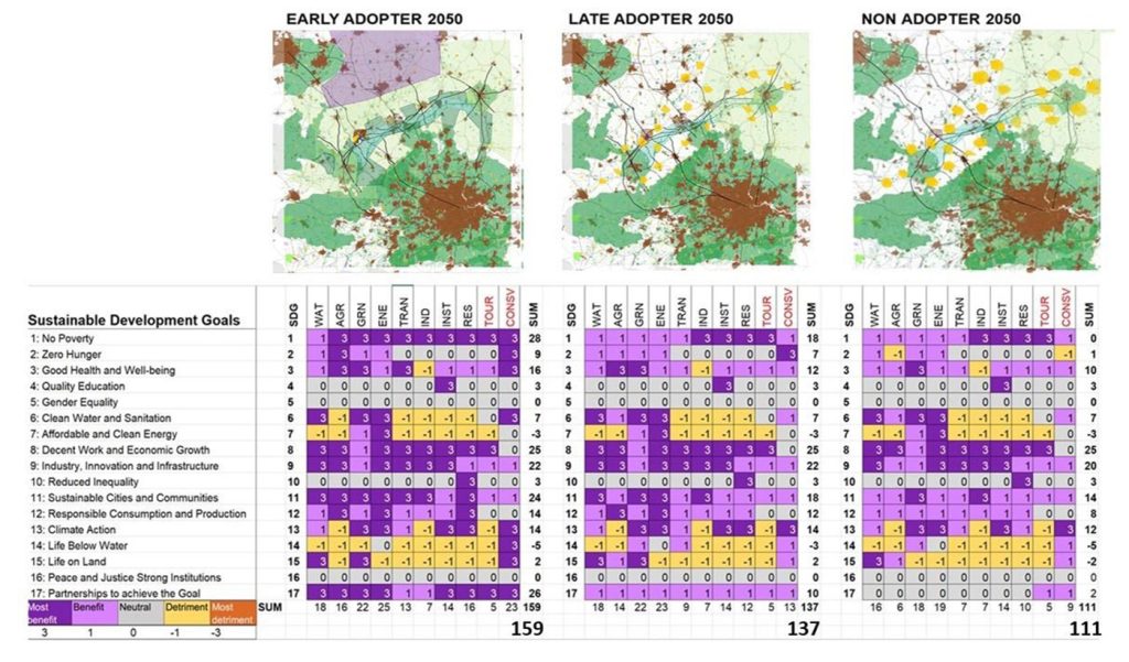
The final scenario-based 2050 designs assessed against the United Nations Sustainable Development Goals.
Source: elaborated by the author.
The advantages of thinking ahead and of concentrating development while planning for the adoption of innovative technologies which would enable retention of the current distributed pattern of development while at the same time substantially increasing landscape protection will likely have the greatest longer-term benefit to the region and its expected population.
The early adoption of strategies to mitigate the negative effects of climate change, and in particular planning, for a major increase in controlled environment agriculture, but also appear to be beneficial to the region and the nation.
At the other extreme, the continued urban sprawl of the CAMKOX region would produce the least benefits to the Sustainable Development Goals and would have the greatest public and private costs while permanently altering much of this highly valued landscape region.
There was also a further post-workshop speculation based on what might occur if London made appropriately selected areas of its greenbelt available for such development after 2035 or 2050 (Figure 19). The Non-Adopter’s CAMKOX design would still satisfy current urban and environmental preferences but there would likely be severe financial pressure on its train infrastructure as well as major negatively perceived change to its landscape character. In contrast, the Early and Late adopter designs would likely be expandable in their innovative infrastructure and urban aspects while retaining the high-quality environmental character of the CAMKOX region.
The purpose of this two-day exercise was to think through strategic alternatives for a complex set of intra- and inter-system relationships among policies and projects, in a future-oriented spatial-temporal manner, and to do this with considerable openness, flexibility and efficiency. All the participants agreed that this geodesign-based exercise was worthwhile, and one which might be a model for how to begin to think strategically about difficult and contentious issues which require a negotiated solution among and with local as well as regional stakeholders, all being an integral part of the planning process.

A two-day Geodesign Workshop.
Source: elaborated by the author.
Afterword
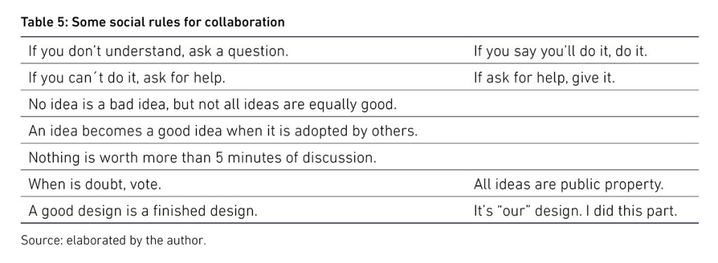
Successful collaborative negotiation among different stakeholders seeking to strike a compromise shifts the paradigm from a zero-sum game to a win-win situation. It requires a different mindset from the participants than the normal “silo-based” practice of defending bureaucratic policies and projects or private profit interests “to the death”. It also requires knowledgeable but neutral leadership. It operates under different social rules (Table 5).
The CAMKOX Corridor workshop was not an official governmental study. It could easily have been. The methods are robust and have been applied to comparable circumstances many times with official public and private participants. I offer three examples in which I have managed the workshops (Rivero et al., 2015, Neuman et al., 2018, and Orland et al., 2019). In each case, the participants were professional and academic people who advise and make these kinds of strategic decisions ■
Acknowledgements
I thank the workshop participants who shall remain anonymous, and the firms whose diagrams we used as the initial basis for geodesign. The photographs were taken by Tess Canfield.
REFERENCIAS
- Ballal, H. (2015). Collaborative Planning with Digital Design Synthesis. [PhD Dissertation], London: Centre for Advanced Spatial Analysis, Faculty of the Built Environment, University College London.
- Ballal, H. (s.f.). Geodesignhub. Recovered from https://www.geodesignhub.com/
- Batty, M. (2013, February). Defining Geodesign (= GIS + Design?). Environment and Planning B: Planning and Design, 40(1), pp. 1–2.
- Fisher, T. R. (2016, December), An Education in Geodesign. Landscape and Urban Planning, (156), pp. 20–22.
- Fisher, T. R., Orland, B. & Steinitz, C. (2020), The International Geodesign Collaboration. Redlands: Esri Press.
- Goodchild, M. F. (2010). Towards geodesign: Repurposing cartography and GIS? Cartographic Perspectives, (66), pp. 7–22.
- Hollstein, L. M. (2019, June). Retrospective and reconsideration: The first 25 years of the Steinitz framework for landscape architecture education and environmental design. Landscape and Urban Planning, (186), pp. 56–66.
- International Geodesign Collaboration-IGC. (n.d.). Changing Geography by Design. [Online]. Recovered from https://www.igc-geodesign.org/
- Malcolm Reading Co. (s.f.). Short list. [Online]. Recovered from https://competitions.malcolmreading.com/cambridgeoxfordconnection/shortlist
- Neuman, M., Tchapi, M., Sharkey, M., Gelgota, A, Itova, I. (2018), East West Arc: Re-thinking Growth in the London Region, University of Westminster, London.
- Orland, B., and Steinitz, C. (2019), Improving our Global Infrastructure: The International Geodesign Collaboration, in Journal of Digital Landscape Architecture, 4-2019, Wichmann, pp 213–221.
- Pettit, C. P., Hawken, S., Ticzon, C., Steinitz, C., Ballal, H., Canfield. T., Leal, S. Z., Lieske. S. N. & Afrooz, A. E. (2019, October). Breaking down the silos through geodesign – Envisioning Sydney’s urban future. Environment and Planning B: Urban Analytics and City Science, 46(8), pp 1–18.
- Rivero, R., Smith, A., Ballal, H., and Steinitz, C. (2015), Promoting Collaborative Geodesign in a Multidisciplinary and Multiscale Environment: Coastal Georgia 2050, USA, Buhmann, E., Ervin, S., and Pietsch, P., (Eds) Digital Landscape Architecture 2015, Herbert Wichmann Press, Germany, pp. 42–58.
- Rowe, P. G. (2017). Design thinking in the digital age. Cambridge/Berlin: Harvard University Graduate School of Design/Sternberg Press.
- Rowe, P. G. (1987). Design thinking, Cambridge: The MIT Press.
- Simon, H. (1996). The Sciences of the Artificial. Cambridge: The MIT Press.
- Steinitz, C. (2017, 10 de octubre). A Digital Workflow for Dynamic Geodesign. [Video file]. Esri Events.
- Recuperado de https://youtu.be/QERJbL9J1Xw
- Steinitz, C. (2012). A Framework for Geodesign. Redlands: Esri Press.
- Steinitz, C. (1990). A Framework for Theory Applicable to the Education of Landscape Architects (and other Environmental Design Professionals). Landscape Journal, 9(2), pp. 136–143.
Cómo citar este artículo (Normas APA):
Steinitz, C. (Noviembre 2021 – Abril 2022). Re-thinking the growth of London. An interactive multi-stakeholder perspective derived in geodesign and negotiation. [En línea]. AREA, 28(1). Recuperado de https://www.area.fadu.uba.ar/area-2801/steinitz2801/